Tuesday's rains, which were particularly heavy southwest and northeast of Houston, are just the start of an extremely wet end of the week. Our city's weather pattern, which included something called a capping inversion that acted a bit like a giant umbrella for the area, has changed allowing Gulf moisture to come flowing in. On Tuesday, that translated to isolated pockets of up to 5 inches of rainfall, particularly northeast of town near Kingwood.
As bad as it was, plenty of areas from downtown to west of the city saw only a trace to about a quarter inch. In a region that covers as much area as we do, these are exactly the kind of unpredictable conditions we can expect. The National Weather Service has been calling for between 2 and 4 inches across the entire region with isolated totals between 7 and 10 inches between now and Sunday. Given what we saw on Tuesday, that seems appropriate, maybe even conservative depending on where you live.
Wednesday and early Thursday appear to be a bit drier than Tuesday, so we should get a respite. However, areas to the north and northwest of the city might not fare as well. A sagging cold front will drape across the region and bring with it the possibility for some potent thunderstorms with high wind and hail. Most forecasters believe they won't make it all the way to Houston, but if you live from say The Woodlands to parts north and west of there, be on the lookout.
By Thursday evening, the front should have pushed into the Houston area and stalled. The key to how much rain we will get starting overnight Thursday will be where it ends up parking itself. The farther south it gets, the lower the chance of the really heavy stuff in the city.
Right now, most forecast models are calling for the greatest accumulations to be south and west of the city, particularly along the coast, but conditions are so unpredictable, it is hard to pinpoint exactly where the heaviest rain will fall and for how long, just as it was Tuesday.
Later on Saturday, it looks like the front will finally push off the coast and we'll begin drying out. Sunday we could even see some clear skies.
Probably the greatest concern at this point in terms of severe flooding will be on low lying streets and along rivers like the Trinity. There is also the problem of saturation flooding in areas where a lot of rain has already fallen. At this point, the best we can say is to be careful and carry and umbrella because it's going to be a wet weekend.
Support Us
Houston's independent source of
local news and culture
account
- Welcome,
Insider - Login
- My Account
- My Newsletters
- Contribute
- Contact Us
Flood Threat This Weekend in Southeast Texas
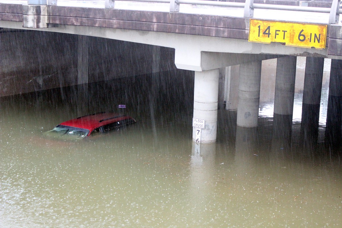
Photo by Abrahan Garza
Lower lying underpasses will be at risk of flash flooding this weekend.
[
          {
            "name": "Related Stories / Support Us Combo",
            "component": "11591218",
            "insertPoint": "4",
            "requiredCountToDisplay": "4"
          },{
            "name": "Air - Billboard - Inline Content",
            "component": "11591214",
            "insertPoint": "2/3",
            "requiredCountToDisplay": "7"
          },{
            "name": "R1 - Beta - Mobile Only",
            "component": "12287027",
            "insertPoint": "8",
            "requiredCountToDisplay": "8"
          },{
            "name": "Air - MediumRectangle - Inline Content - Mobile Display Size 2",
            "component": "11591215",
            "insertPoint": "12",
            "requiredCountToDisplay": "12"
          },{
            "name": "Air - MediumRectangle - Inline Content - Mobile Display Size 2",
            "component": "11591215",
            "insertPoint": "4th",
            "startingPoint": "16",
            "requiredCountToDisplay": "12"
          }

            ,{
              "name": "RevContent - In Article",
              "component": "12527128",
              "insertPoint": "3/5",
              "requiredCountToDisplay": "5"
            }

        ]
Use of this website constitutes acceptance of our
terms of use,
our cookies policy, and our
privacy policy
The Houston Press may earn a portion of sales from products & services purchased through links on our site from our
affiliate partners.
©2024
Houston Press, LP. All rights reserved.
