Tropical Storm Beta has been pouring down rain across the Houston area since Monday night, and its rain bands will continue to cause potentially heavy rainfall for at least the next 24 hours as Beta moves east at about 2 miles per hour. The storm was downgraded to a tropical depression in the wee hours of Tuesday morning, but that doesn't mean Houston is in the clear just yet.
“They’re dropping water, sometimes 2 to 3 inches per hour, so we’ve gotten a considerable amount of rain, and it’s going to continue throughout the rest of the day and into the night,” Houston Mayor Sylvester Turner said in a Tuesday morning weather update from the city’s Office of Emergency Management.
At 8:10 a.m. Tuesday, Space City Weather updated its Flood Scale alert from Stage 2 to Stage 3 for the Houston metro area south of I-10, forecasting the potential for “significant flash flooding” similar to what occurred during Tropical Storm Imelda last year and the 2016 Memorial Weekend floods.

Houston Mayor Sylvester Turner told Houston residents to stay home if possible due to street flooding caused by Tropical Storm Beta.
Screenshot
Turner said that all non-essential city employees have been told to stay home today, and recommended that local businesses follow suit, although Tuesday’s virtual City Council meeting is still going on as scheduled. He cited the rapid rate at which Tropical Storm Imelda intensified last year and the widespread highway flooding that followed as reasons why Houston area residents should stay off the roads if at all possible.
“I-45 at North Main turned into a lake because that water came so very quickly,” Turner said. “More than 100 vehicles were stranded, and we don’t want to see that repeat itself.”
“We’ve had a lot of streets flooding, especially in the southern part and the southwest part of the city of Houston,” Turner continued. He said that Keegans Bayou in Fort Bend County rose above its banks late Monday night, but has now receded, and that the city has placed road barricades at more than 70 locations around Houston. So far, the city hasn’t received any calls about structural flooding, Turner said. Street flooding has also been reported around Rice University on University Boulevard, and downtown near Milam and Congress as well.
In a separate press conference Tuesday afternoon, Harris County Judge Lina Hidalgo urged people to continue to stay off the roads, saying: "Your sedan is not a submarine. Your minivan is not magical... I know a lot of people in Harris County have some great trucks, but your destination is not worth your life. It's not worth the life of the first responder that's gonna have to come and rescue you."
Hidalgo and Harris County Flood Control's Jeff Lindner both reassured county residents who live near the Barker and Addicks reservoirs that there have not been any controlled releases from either reservoir as there were during Hurricane Harvey, and that any flooding in the area is solely due to high rain.
"There are no releases currently from Addicks and Barker reservoirs, and both of these reservoirs have capacity to handle additional rainfall," Lindner said.
Chief George Buenik of the city’s Office of Emergency Management said that three local bayous “are at or near bank” within the city limits as of Tuesday morning: Buffalo Bayou at Milam, Shepherd and Piney Point, Briar Branch at Campbell, and Brays Bayou at South Main and at Lawndale.
Houston Police Chief Art Acevedo said that Highway 288 between I-45 and 610 as well as the I-45 northbound HOV lane are currently shut down “because of flooding.” He said that HPD carried out four high water rescues overnight and 27 since 6 a.m. Tuesday, and that 24 cars have been towed due to getting stuck in flooded roadways.
Houston Fire Chief Sam Peña said that the fire department has carried out “over 60 rescues and evacuations” since 8 p.m. Monday, all of which were due to street-level flooding.
“It only takes a foot of water to sweep your car away and throw it downstream, and cause a tragedy,” Peña said.

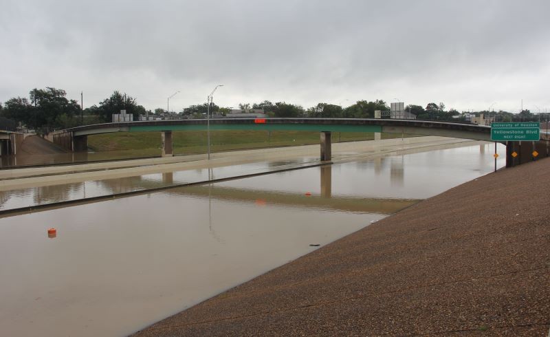
Drivers dealt with street flooding Tuesday morning at University Boulevard and Lanier Drive just outside of Rice University.
Photo by Schaefer Edwards
Beta is expected to pass fully out of the Houston area by Wednesday afternoon, but there’s no telling how much rain it’ll drop in the meantime.
“We could get anywhere from four to six to ten inches of rain. We just don’t know,” Turner said.
So far, there has only been one high water rescue in Harris County outside of Houston, Hidalgo said. The county is keeping a close eye on Clear Creek, which is still continuing to rise in some areas, Lindner said.


"We do have flooding along all of Clear Creek, from Pearland all the way down to Clear Lake and Galveston Bay," Lindner said. "We do have some structure flooding on both sides of the creek on the Harris and also the Galveston and Brazoria County sides of the creek," he continued.
"Any time between now and when the storm moves away around [the] afternoon tomorrow, we could see a new band of rain that could cause flooding to structures... We need to keep watching and be very careful," Hidalgo said.

